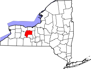
National Register of Historic Places listings in Ontario County, New York
Map all coordinates using OpenStreetMap
Download coordinates as:
- KML
- GPX (all coordinates)
- GPX (primary coordinates)
- GPX (secondary coordinates)
List of the National Register of Historic Places listings in Ontario County, New York
This is intended to be a complete list of properties and districts listed on the National Register of Historic Places in Ontario County, New York. The locations of National Register properties and districts (at least for all showing latitude and longitude coordinates below) may be seen in a map by clicking on "Map of all coordinates".[1] One property, Boughton Hill, is further designated a National Historic Landmark.
Map all coordinates using OpenStreetMap
Download coordinates as:
- KML
- GPX (all coordinates)
- GPX (primary coordinates)
- GPX (secondary coordinates)
This National Park Service list is complete through NPS recent listings posted June 7, 2024.[2]
| Albany (Albany) – Allegany – Bronx – Broome – Cattaraugus – Cayuga – Chautauqua – Chemung – Chenango – Clinton – Columbia – Cortland – Delaware – Dutchess (Poughkeepsie, Rhinebeck) – Erie (Buffalo) – Essex – Franklin – Fulton – Genesee – Greene – Hamilton – Herkimer – Jefferson – Kings – Lewis – Livingston – Madison – Monroe (Rochester) – Montgomery – Nassau – New York (Below 14th Street, 14th to 59th Streets, 59th to 110th Streets, Above 110th Street, Islands) – Niagara (Niagara Falls) – Oneida – Onondaga (Syracuse) – Ontario – Orange – Orleans – Oswego – Otsego – Putnam – Queens – Rensselaer – Richmond – Rockland – St. Lawrence – Saratoga – Schenectady – Schoharie – Schuyler – Seneca – Steuben – Suffolk – Sullivan – Tioga – Tompkins – Ulster – Warren – Washington – Wayne – Westchester (Northern, Southern, New Rochelle, Peekskill, Yonkers) – Wyoming – Yates |
County-wide listings
| [3] | Name on the Register | Image | Date listed[4] | Location | City or town | Description |
|---|---|---|---|---|---|---|
| 1 | Adelaide Avenue School | 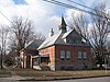 | April 26, 1984 (#84002822) | 108-116 Adelaide Ave. 42°53′01″N 77°17′10″W / 42.883611°N 77.286111°W / 42.883611; -77.286111 (Adelaide Avenue School) | Canandaigua | |
| 2 | Ashcroft |  | November 20, 1975 (#75001218) | 112 Jay St. 42°51′13″N 76°59′09″W / 42.853611°N 76.985833°W / 42.853611; -76.985833 (Ashcroft) | Geneva | Gothic Revival home designed by Calvert Vaux |
| 3 | Levi Barden Cobblestone Farmhouse | 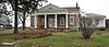 | July 25, 2003 (#03000690) | 5300 Wabash Rd. 42°46′16″N 77°02′18″W / 42.771111°N 77.038333°W / 42.771111; -77.038333 (Levi Barden Cobblestone Farmhouse) | Seneca | |
| 4 | Thomas Barron House |  | October 6, 1988 (#88001854) | 1160 Canandaigua Rd. 42°51′45″N 77°02′01″W / 42.8625°N 77.033611°W / 42.8625; -77.033611 (Thomas Barron House) | Seneca | |
| 5 | Belhurst Castle | 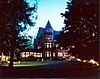 | January 29, 1987 (#86003728) | Lochland Rd. 42°50′18″N 76°58′39″W / 42.838333°N 76.9775°W / 42.838333; -76.9775 (Belhurst Castle) | Geneva | House on Seneca Lake, now a restaurant and inn |
| 6 | Benham House | 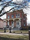 | April 26, 1984 (#84002823) | 280-282 S. Main St. 42°52′59″N 77°16′45″W / 42.883056°N 77.279167°W / 42.883056; -77.279167 (Benham House) | Canandaigua | |
| 7 | Boughton Hill | 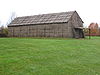 | October 15, 1966 (#66000559) | Address Restricted | Victor | Also known as Ganondagan State Historic Site |
| 8 | Brigham Hall |  | September 29, 1984 (#84002827) | 229 Bristol St. 42°52′45″N 77°17′23″W / 42.879167°N 77.289722°W / 42.879167; -77.289722 (Brigham Hall) | Canandaigua | |
| 9 | Bristol Center Methodist Episcopal Church | Upload image | October 28, 2022 (#100008319) | 4471 NY 64 42°48′40″N 77°23′29″W / 42.8111°N 77.3914°W / 42.8111; -77.3914 (Bristol Center Methodist Episcopal Church) | Bristol | |
| 10 | Building at 426 South Main Street | 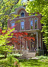 | April 26, 1984 (#84002850) | 426 S. Main St. 42°52′52″N 77°16′37″W / 42.881111°N 77.276944°W / 42.881111; -77.276944 (Building at 426 South Main Street) | Canandaigua | 1880 brick house and contributing barn in rear are a rare older house remaining in that neighborhood |
| 11 | Canandaigua Historic District |  | April 26, 1984 (#84002856) | Catherine, Dungan, Brook, Hubble & Sly Sts., portions of Park, Wood, Washington, Howell, Bemis, Main & Gibson Sts. 42°53′24″N 77°16′59″W / 42.890000°N 77.283056°W / 42.890000; -77.283056 (Canandaigua Historic District) | Canandaigua | Core of county seat with many intact 19th- and early 20th-century commercial buildings; boundaries increased on June 7, 2016 |
| 12 | Canandaigua Veterans Hospital Historic District |  | March 27, 2012 (#12000161) | 400 Fort Hill Avenue 42°54′04″N 77°16′11″W / 42.901197°N 77.269734°W / 42.901197; -77.269734 (Canandaigua Veterans Hospital Historic District) | Canandaigua | United States Second Generation Veterans Hospitals Multiple Property Submission |
| 13 | Central Naples Historic District | Upload image | April 4, 2024 (#100008554) | Portions of Academy, Cross, Dumond, Elizabeth, Lyon, Mechanic, Mill, Monier, Ontario, North Main, Reed, South Main, Thrall, and Wall Sts., East and West Aves. 42°36′49″N 77°24′14″W / 42.6135°N 77.4039°W / 42.6135; -77.4039 (Central Naples Historic District) | Naples | |
| 14 | Thaddeus Chapin House |  | April 26, 1984 (#84002861) | 128 Thad Chapin St. 42°52′55″N 77°17′30″W / 42.881944°N 77.291667°W / 42.881944; -77.291667 (Thaddeus Chapin House) | Canandaigua | |
| 15 | Ephraim Cleveland House | 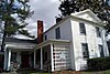 | February 18, 1994 (#94000047) | 201 N. Main St. 42°37′34″N 77°23′41″W / 42.626111°N 77.394722°W / 42.626111; -77.394722 (Ephraim Cleveland House) | Naples | |
| 16 | Clifton Springs Sanitarium | 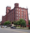 | April 6, 1979 (#79001615) | 11 and 9 E. Main St 42°57′40″N 77°08′14″W / 42.961111°N 77.137222°W / 42.961111; -77.137222 (Clifton Springs Sanitarium) | Clifton Springs | |
| 17 | Clifton Springs Sanitarium Historic District |  | May 24, 1990 (#90000818) | E. Main St. between Crane and Prospect 42°57′40″N 77°08′13″W / 42.961111°N 77.136944°W / 42.961111; -77.136944 (Clifton Springs Sanitarium Historic District) | Clifton Springs | |
| 18 | Cobblestone Manor |  | April 26, 1984 (#84002862) | 495 N. Main St. 42°54′08″N 77°17′30″W / 42.902222°N 77.291667°W / 42.902222; -77.291667 (Cobblestone Manor) | Canandaigua | |
| 19 | Cobblestone Railroad Pumphouse | 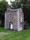 | May 22, 1992 (#92000551) | Main St. 43°00′31″N 77°28′02″W / 43.008611°N 77.467222°W / 43.008611; -77.467222 (Cobblestone Railroad Pumphouse) | Victor | |
| 20 | Jeremiah Cronkite House | 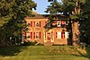 | February 5, 2002 (#01001563) | 1095 Lynaugh Rd. 42°58′59″N 77°23′51″W / 42.983056°N 77.3975°W / 42.983056; -77.3975 (Jeremiah Cronkite House) | Victor | |
| 21 | John and Mary Dickson House |  | November 19, 2008 (#08001077) | 9010 Main St. 42°54′20″N 77°32′19″W / 42.905556°N 77.538611°W / 42.905556; -77.538611 (John and Mary Dickson House) | West Bloomfield, New York | |
| 22 | East Bloomfield Historic District |  | November 13, 1989 (#89001947) | Roughly Main, South, Park Sts. and NY 5 42°53′43″N 77°26′04″W / 42.8953°N 77.4344°W / 42.8953; -77.4344 (East Bloomfield Historic District) | East Bloomfield | |
| 23 | Fairview Cemetery | Upload image | November 20, 2023 (#100009097) | North side of Mount Pleasant St. west of North Main St. 42°37′33″N 77°23′46″W / 42.6259°N 77.396°W / 42.6259; -77.396 (Fairview Cemetery) | Naples | |
| 24 | Farmers and Merchants Bank |  | February 28, 2008 (#08000102) | 24-26 Linden St. 42°52′03″N 76°59′02″W / 42.8675°N 76.9839°W / 42.8675; -76.9839 (Farmers and Merchants Bank) | Geneva | |
| 25 | Farmington Quaker Crossroads Historic District | Upload image | April 25, 2007 (#07000384) | Cty Rd. 8 at Sheldon Rd. 43°01′41″N 77°19′19″W / 43.0281°N 77.3220°W / 43.0281; -77.3220 (Farmington Quaker Crossroads Historic District) | Farmington | |
| 26 | Felt Cobblestone General Store |  | May 22, 1992 (#92000553) | 6452 Victor-Manchester Rd. 42°58′28″N 77°22′53″W / 42.9744°N 77.3814°W / 42.9744; -77.3814 (Felt Cobblestone General Store) | Victor | |
| 27 | First Baptist Church | Upload image | October 10, 2002 (#02001118) | 134 N. Main St. 42°52′16″N 76°59′15″W / 42.8711°N 76.9875°W / 42.8711; -76.9875 (First Baptist Church) | Geneva | |
| 28 | First Baptist Church of Phelps |  | May 22, 1992 (#92000554) | 40 Church St. 42°57′18″N 77°03′31″W / 42.955°N 77.0586°W / 42.955; -77.0586 (First Baptist Church of Phelps) | Phelps | |
| 29 | Genesee Park Historic District | Upload image | October 10, 2002 (#02001117) | Genesee Park, Genesee Park Place, and Genesee and Lewis Sts. 42°52′16″N 76°59′02″W / 42.8711°N 76.9839°W / 42.8711; -76.9839 (Genesee Park Historic District) | Geneva | |
| 30 | Geneva Armory | 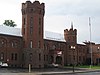 | March 2, 1995 (#95000082) | 300 Main St. 42°52′01″N 76°59′07″W / 42.8669°N 76.9853°W / 42.8669; -76.9853 (Geneva Armory) | Geneva | |
| 31 | Geneva Commercial Historic District |  | May 13, 2014 (#14000225) | 8-156 Castle, 16 & 20 E. Castle, 396-555 Exchange, 20-120 Seneca, 24-52 Linden & 317, 319, 325 & 329 Main Sts. 42°52′04″N 76°59′01″W / 42.86772°N 76.98349°W / 42.86772; -76.98349 (Geneva Commercial Historic District) | Geneva | |
| 32 | Geneva Hall and Trinity Hall, Hobart & William Smith College |  | July 16, 1973 (#73001241) | S. Main St. 42°51′29″N 76°58′57″W / 42.8581°N 76.9825°W / 42.8581; -76.9825 (Geneva Hall and Trinity Hall, Hobart & William Smith College) | Geneva | |
| 33 | William W. Gorham House | Upload image | June 7, 2024 (#100010386) | 5266 Parrish Street Extension 42°51′56″N 77°18′17″W / 42.8656°N 77.3046°W / 42.8656; -77.3046 (William W. Gorham House) | Canandaigua | |
| 33 | Granger Cottage |  | April 26, 1984 (#84002865) | 60 Granger St. 42°53′51″N 77°17′07″W / 42.8976°N 77.2852°W / 42.8976; -77.2852 (Granger Cottage) | Canandaigua | |
| 34 | Francis Granger House |  | April 26, 1984 (#84002867) | 426 N. Main St. 42°54′02″N 77°17′29″W / 42.9006°N 77.2914°W / 42.9006; -77.2914 (Francis Granger House) | Canandaigua | |
| 35 | Harmon Cobblestone Farmhouse and Cobblestone Smokehouse | Upload image | May 22, 1992 (#92000552) | 983 Smith Rd. 42°59′31″N 77°07′29″W / 42.9919°N 77.1247°W / 42.9919; -77.1247 (Harmon Cobblestone Farmhouse and Cobblestone Smokehouse) | Phelps | |
| 36 | Dr. John Quincy Howe House | 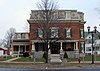 | February 5, 2002 (#01001564) | 66 Main St. 42°57′26″N 77°03′22″W / 42.9572°N 77.0561°W / 42.9572; -77.0561 (Dr. John Quincy Howe House) | Phelps | |
| 37 | William Huffman Cobblestone House | Upload image | December 31, 2002 (#02001647) | 1064 Townline Rd. 42°59′04″N 76°58′06″W / 42.9844°N 76.9683°W / 42.9844; -76.9683 (William Huffman Cobblestone House) | Phelps | |
| 38 | Knights of the Maccabees Hall | Upload image | June 13, 2013 (#13000371) | 4270 NY 21 42°53′58″N 77°15′59″W / 42.8994°N 77.26640°W / 42.8994; -77.26640 (Knights of the Maccabees Hall) | Cheshire | |
| 39 | Marshall House |  | April 26, 1984 (#84002869) | 274 Bristol St. 42°52′49″N 77°17′29″W / 42.8803°N 77.2914°W / 42.8803; -77.2914 (Marshall House) | Canandaigua | |
| 40 | Miller Corsets, Inc. Factory |  | August 27, 2020 (#100005473) | 10 Chapin St. 42°53′12″N 77°16′54″W / 42.8868°N 77.2817°W / 42.8868; -77.2817 (Miller Corsets, Inc. Factory) | Canandaigua | |
| 41 | Morgan Hook and Ladder Company |  | June 2, 1995 (#95000668) | 18-20 Mill St. 42°36′55″N 77°24′13″W / 42.6153°N 77.4036°W / 42.6153; -77.4036 (Morgan Hook and Ladder Company) | Naples | |
| 42 | Naples Memorial Town Hall | 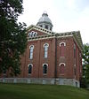 | May 13, 1996 (#96000482) | N. Main St., northeast corner of the junction of N. Main and Monier Sts. 42°37′02″N 77°24′02″W / 42.6172°N 77.4006°W / 42.6172; -77.4006 (Naples Memorial Town Hall) | Naples | |
| 43 | Naples South Main Street Historic District | Upload image | November 14, 2022 (#100008347) | Portions of James, South Main, Reed, Sprague, and Weld Sts. 42°36′48″N 77°24′14″W / 42.6134°N 77.4038°W / 42.6134; -77.4038 (Naples South Main Street Historic District) | Naples | |
| 44 | Naples Viniculture Historic District | Upload image | November 15, 2022 (#100008381) | Portions of North Main St., Tobey St., and West Ave. 42°37′27″N 77°23′55″W / 42.6241°N 77.3986°W / 42.6241; -77.3986 (Naples Viniculture Historic District) | Naples | |
| 45 | Nester House | 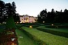 | April 9, 1984 (#84002873) | 1001 Lochland Rd. 42°50′55″N 76°58′48″W / 42.8486°N 76.98°W / 42.8486; -76.98 (Nester House) | Geneva | |
| 46 | North Main Street Historic District |  | July 20, 1973 (#73001239) | Between RR tracks and Buffalo-Chapel St. 42°53′35″N 77°17′08″W / 42.893056°N 77.285556°W / 42.893056; -77.285556 (North Main Street Historic District) | Canandaigua | |
| 47 | Ontario and Livingston Mutual Insurance Office |  | November 21, 2008 (#08001078) | 9018 Main St. 42°54′22″N 77°32′16″W / 42.906029°N 77.537827°W / 42.906029; -77.537827 (Ontario and Livingston Mutual Insurance Office) | West Bloomfield | |
| 48 | Osborne House | 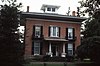 | July 11, 1980 (#80002732) | 146 Maple Ave. 42°58′42″N 77°24′38″W / 42.978333°N 77.410556°W / 42.978333; -77.410556 (Osborne House) | Victor | |
| 49 | Parrott Hall | Upload image | August 12, 1971 (#71000553) | W. North St. between Castle St. and Preemption Rd. 42°52′36″N 77°00′30″W / 42.876667°N 77.008333°W / 42.876667; -77.008333 (Parrott Hall) | Geneva | |
| 50 | Watrous Peck House |  | March 13, 2017 (#100000756) | 8814 Wesley Rd. 42°52′09″N 77°31′25″W / 42.86913°N 77.52361°W / 42.86913; -77.52361 (Watrous Peck House) | West Bloomfield | 1803 New England-style Georgian house built by settler from that region |
| 51 | Phelps Town Hall |  | April 25, 1996 (#96000485) | 79 Main St. 42°57′25″N 77°03′28″W / 42.956944°N 77.057778°W / 42.956944; -77.057778 (Phelps Town Hall) | Phelps | |
| 52 | Port Gibson United Methodist Church | Upload image | November 29, 1996 (#96001387) | 2951 Greig St. 43°02′13″N 77°09′23″W / 43.036944°N 77.156389°W / 43.036944; -77.156389 (Port Gibson United Methodist Church) | Port Gibson | |
| 53 | Rippey Cobblestone Farmhouse | Upload image | October 6, 1992 (#92001051) | 1227 Leet Rd. 42°50′28″N 77°02′19″W / 42.841111°N 77.038611°W / 42.841111; -77.038611 (Rippey Cobblestone Farmhouse) | Seneca | |
| 54 | St. Bridget's Roman Catholic Church Complex |  | August 28, 1992 (#92001052) | 15 Church St., between Church and Michigan Sts. 42°54′02″N 77°25′57″W / 42.900556°N 77.4325°W / 42.900556; -77.4325 (St. Bridget's Roman Catholic Church Complex) | Bloomfield | |
| 55 | St. Francis de Sales Parish Complex | Upload image | August 10, 2015 (#15000514) | 94, 110, 130 & 140 Exchange St. 42°52′24″N 76°58′47″W / 42.873265°N 76.979756°W / 42.873265; -76.979756 (St. Francis de Sales Parish Complex) | Geneva | Complex built over 10 years beginning in 1864 reflects the rapid growth of the city's Catholic population |
| 56 | St. John's Episcopal Church | Upload image | November 7, 1978 (#78001892) | Church St. 42°57′23″N 77°03′28″W / 42.956389°N 77.057778°W / 42.956389; -77.057778 (St. John's Episcopal Church) | Phelps | |
| 57 | St. Peter's Episcopal Church |  | November 29, 1996 (#96001389) | 44 Main St. 42°54′01″N 77°25′28″W / 42.900278°N 77.424444°W / 42.900278; -77.424444 (St. Peter's Episcopal Church) | Bloomfield | |
| 58 | Saltonstall Street School |  | April 26, 1984 (#84002877) | 47 Saltonstall St. 42°53′03″N 77°16′36″W / 42.884167°N 77.276667°W / 42.884167; -77.276667 (Saltonstall Street School) | Canandaigua | |
| 59 | Seneca Presbyterian Church | Upload image | May 25, 1973 (#73001242) | East of Stanley off NY 245 on Number Nine Rd. 42°48′20″N 77°03′05″W / 42.805556°N 77.051389°W / 42.805556; -77.051389 (Seneca Presbyterian Church) | Stanley | |
| 60 | Smith Observatory and Dr. William R. Brooks House | Upload image | April 11, 2008 (#08000275) | 618-620 Castle St. 42°52′20″N 77°00′11″W / 42.872097°N 77.003111°W / 42.872097; -77.003111 (Smith Observatory and Dr. William R. Brooks House) | Geneva | |
| 61 | Smith's Opera House |  | October 10, 1979 (#02001454) | 82 Seneca St. 42°52′02″N 76°59′03″W / 42.867111°N 76.984083°W / 42.867111; -76.984083 (Smith's Opera House) | Geneva | |
| 62 | Sonnenberg Gardens |  | September 28, 1973 (#73001240) | 151 Charlotte St. 42°54′00″N 77°16′21″W / 42.9°N 77.2725°W / 42.9; -77.2725 (Sonnenberg Gardens) | Canandaigua | |
| 63 | South Bristol Grange Hall 1107 | Upload image | December 19, 1997 (#97001528) | 6457 NY 64 42°42′28″N 77°22′50″W / 42.707778°N 77.380556°W / 42.707778; -77.380556 (South Bristol Grange Hall 1107) | Bristol Springs | |
| 64 | South Farmington Friends Cemetery and Meetinghouse Site | Upload image | February 2, 2024 (#100009878) | 4899 Shortsville Rd & County Road 28 42°57′24″N 77°16′45″W / 42.9568°N 77.2791°W / 42.9568; -77.2791 (South Farmington Friends Cemetery and Meetinghouse Site) | Farmington | |
| 65 | South Main Street Historic District |  | December 31, 1974 (#74001286) | Irregular pattern along S. Main St. 42°51′27″N 76°58′59″W / 42.8575°N 76.983056°W / 42.8575; -76.983056 (South Main Street Historic District) | Geneva | |
| 66 | Philetus Swift House | Upload image | March 15, 2005 (#05000159) | 866 NY 96 42°56′56″N 77°01′06″W / 42.948889°N 77.018333°W / 42.948889; -77.018333 (Philetus Swift House) | Phelps | |
| 67 | US Post Office-Canandaigua |  | November 17, 1988 (#88002465) | 28 N. Main St. 42°53′18″N 77°16′57″W / 42.8883°N 77.2825°W / 42.8883; -77.2825 (US Post Office-Canandaigua) | Canandaigua | Neoclassical structure completed in 1910 with front facade modeled after Erechtheion on the Acropolis in Athens. One of only three post offices in the state designed by private architects under the Tarsney Act. |
| 68 | US Post Office-Geneva |  | May 11, 1989 (#88002523) | 67 Castle St. 42°52′03″N 76°59′07″W / 42.8675°N 76.9853°W / 42.8675; -76.9853 (US Post Office-Geneva) | Geneva | |
| 69 | Valentown Hall |  | May 9, 1997 (#97000425) | Jct. of High St. and Valentown Rd. 43°01′34″N 77°26′09″W / 43.0261°N 77.4358°W / 43.0261; -77.4358 (Valentown Hall) | Victor | |
| 70 | Oliver Warner Farmstead | Upload image | November 17, 1988 (#88002189) | NY 88 42°54′51″N 77°07′51″W / 42.9142°N 77.1308°W / 42.9142; -77.1308 (Oliver Warner Farmstead) | Clifton Springs | |
| 71 | Warren–Benham House | Upload image | November 9, 2017 (#100001805) | 5680 Seneca Point Rd. 42°44′40″N 77°20′24″W / 42.7444°N 77.3400°W / 42.7444; -77.3400 (Warren–Benham House) | Bristol Springs | 1924 Tudor-style house was one of the first vacation cottages built in the area |
| 72 | Washington Street Cemetery | Upload image | June 4, 2002 (#02000616) | Washington St. 42°51′44″N 76°59′27″W / 42.8622°N 76.9908°W / 42.8622; -76.9908 (Washington Street Cemetery) | Geneva | |
| 73 | George and Addison Wheeler House | Upload image | March 15, 2005 (#05000168) | 6353 and 6342 Grimble Rd. 42°51′33″N 77°22′22″W / 42.8592°N 77.3728°W / 42.8592; -77.3728 (George and Addison Wheeler House) | East Bloomfield | Boundary increase approved December 28, 2020 |
| 74 | Wilder Cemetery |  | March 23, 2003 (#03000130) | NY 64 42°44′08″N 77°23′53″W / 42.7356°N 77.3981°W / 42.7356; -77.3981 (Wilder Cemetery) | S. Bristol | |
| 75 | Woodlawn Cemetery |  | November 12, 2014 (#14000914) | 130 N. Pearl St. 42°53′18″N 77°17′56″W / 42.8883°N 77.2989°W / 42.8883; -77.2989 (Woodlawn Cemetery) | Canandaigua | Last resting place of many important early residents, Woodlawn shows the evolution from a churchyard cemetery to a rural one |
See also
Wikimedia Commons has media related to National Register of Historic Places in Ontario County, New York.
References
- ^ The latitude and longitude information provided in this table was derived originally from the National Register Information System, which has been found to be fairly accurate for about 99% of listings. Some locations in this table may have been corrected to current GPS standards.
- ^ National Park Service, United States Department of the Interior, "National Register of Historic Places: Weekly List Actions", retrieved June 7, 2024.
- ^ Numbers represent an alphabetical ordering by significant words. Various colorings, defined here, differentiate National Historic Landmarks and historic districts from other NRHP buildings, structures, sites or objects.
- ^ The eight-digit number below each date is the number assigned to each location in the National Register Information System database, which can be viewed by clicking the number.
- v
- t
- e
U.S. National Register of Historic Places in New York

by county
- Albany
- Allegany
- Bronx
- Broome
- Cattaraugus
- Cayuga
- Chautauqua
- Chemung
- Chenango
- Clinton
- Columbia
- Cortland
- Delaware
- Dutchess
- Erie
- Essex
- Franklin
- Fulton
- Genesee
- Greene
- Hamilton
- Herkimer
- Jefferson
- Kings (Brooklyn)
- Lewis
- Livingston
- Madison
- Monroe
- Montgomery
- Nassau
- New York (Manhattan)
- Niagara
- Oneida
- Onondaga
- Ontario
- Orange
- Orleans
- Oswego
- Otsego
- Putnam
- Queens
- Rensselaer
- Richmond (Staten Island)
- Rockland
- Saratoga
- Schenectady
- Schoharie
- Schuyler
- Seneca
- St. Lawrence
- Steuben
- Suffolk
- Sullivan
- Tioga
- Tompkins
- Ulster
- Warren
- Washington
- Wayne
- Westchester
- Wyoming
- Yates
by city
 Category
 List
List National Register of Historic Places Portal


